South Cumberland State Park
Taking a hike on Fiery Gizzard Trail in South Cumberland State Park
On April 3 2023, we headed north to Tennessee. Just an hour or so west of Chattanooga is South Cumberland State Park. This park is very spread out across three different counties – but we started in Monteagle, where the Visitor’s Center is located. The Visitor’s Center is not located where you would expect. It is in a residential area. From the Visitor’s Center you will have to drive to the different trail locations.
Outside of the Visitor’s Center, a hawk named Artemis is there to greet you. Artemis is injured and she cannot live in the wild anymore, so her new home is South Cumberland! It was pretty cool to be able to see such a big bird up close. Inside the Visitor’s Center is a museum with an exhibit about the flora, fauna, and history of the park.
We did not know this beforehand, but unlike Georgia State Parks, the maps are not free in Tennessee State Parks. But that is OK! The maps are only $2. We definitely recommend buying one for the trail. After talking to a park ranger about where to hike, we decided to drive to the north end of the Fiery Gizzard Trail.
Fiery Gizzard is a 11.75 mile trail that starts in Tracy City. The drive from the Visitor’s Center to Tracy City was about 10 minutes. We decided to do the North Trailhead because the park ranger said it was scenic, there were waterfalls, and it was easier than the South Trailhead. Plus, it was closer to the Visitor’s Center. There is a small parking lot at the trailhead. When we went, it was on a Monday, so parking was not an issue.
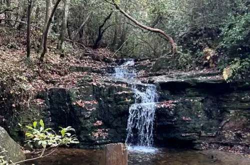
First off, this trail was amazing! We knew about 5 minutes into the hike that this trail was unlike anything we had hiked before. I had never hiked anywhere in the Cumberland Plateau region of Tennessee, but I am so glad we chose it! This hike followed a creek the entire time. On the trail, we saw 3 waterfalls. There were also rock formations along the trail that made it very different from what we are used to in North Georgia.
This hike followed a creek the entire time – on the trail, we saw 3 waterfalls
After we walked about a mile and a half down the trail, we went back the way we came. When we got to the Grundy Forest loop, we went a different way than when we came down. The other half of the loop is near hike-in campsites and an old CCC campground.
Overall, I would say that this trail is moderate. There were some steep areas on the trail. The trail also had many places that were completely covered in tree roots. When we went, it was rainy, and the tree roots were extremely slick. This is definitely a trail to wear hiking boots on instead of tennis shoes because of the uneven terrain. The trail is well marked.
We will definitely be going back to South Cumberland State Park. We only did about 3.5 miles of it, and there is so much more to see! After the park, we headed about 30 minutes back down the highway to Jasper, TN to visit the Top of the Rock Restaurant and Brewery.
Overall, this was an awesome day trip. We plan to go back to South Cumberland State Park to do more of the Fiery Gizzard Trail. I can’t wait to eat on the outside patio of Top of the Rock after that hike, too!
If you love rugged plateau hikes and big waterfall views at South Cumberland, you’ll also want to plan a day at Fall Creek Falls State Park, home to one of the tallest waterfalls in the eastern United States.
If you’re hooked on rugged plateau terrain and deep gorges at South Cumberland, you’ll also love North Chickamauga Creek Gorge, with its narrow canyon walls, creek side trails, and swimming holes.
Tips for your trip to South Cumberland State Park:
- Go to the Visitor’s Center first! The park rangers are knowledgeable and will help you pick out a hike that fits you best.
- The park is not in the middle of nowhere – the Visitor’s Center and trailhead were in residential areas.
- Be careful on the trail. Although the trail is well marked, it can be covered in roots or rocks in some places, making it slick.
- Buy a map! It is only $2 and it is worth it.
South Cumberland State Park
Welcome Center
11745 US 41
Monteagle, TN 37356
Fiery Gizzard North Trailhead
131 Fiery Gizzard Road
Tracy City, TN 37387
Last Updated on January 13, 2026


More to Explore

Florence Marina State Park
Cascade Falls at F.D. Roosevelt State Park